 Live Music Archive
 Librivox Free Audio
 Metropolitan Museum
 Cleveland Museum of Art
 Internet Arcade
 Console Living Room
 Books to Borrow
 Open Library
 TV News
 Understanding 9/11
tv Caught on Camera MSNBC October 28, 2012 2:00pm-3:00pm PDT
2:00 pm

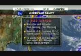
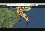
♪ playing a lone hand ♪ my life begins today ♪ ♪ fly by night away from here ♪ ♪ change my life again ♪ ♪ fly by night, goodbye my dear ♪ ♪ my ship isn't coming ♪ and i just can't pretend oww! ♪ [ male announcer ] careful, you're no longer invisible in a midsize sedan. the volkswagen passat. winner of a motor trend midsize sedan comparison. that's the power of german engineering. hi everybody. good afternoon. it's 5:00 p.m. on the east coast. you're watching msnbc's continuing coverage of hurricane sandy. at this hour sandy is now a category 1 hurricane packing winds estimated at 75 miles per hour. even though this hurricane is not expected to make its official landfall until late tomorrow night or early tuesday morning, sandy's outer bands are
2:01 pm
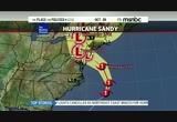
already beginning to batter the outer banks of north carolina. i'm thomas roberts here in new york. we appreciate you spending time with us. we have full team coverage this afternoon and through this evening of what is shaping up to be an historic storm. we have reporters stationed up and down the eastern coastline tracking hurricane sandy's path. we'll be getting to all of them in a moment. the very latest enough from president obama who is officially off the campaign trail just wrapping up a stop at fema headquarters in washington, d.c. a short time ago. the president was briefed by fema's regional directors and then he addressed the american people. >> it's going to be very important that populations in all the impacted states take this seriously, listen to your state and local elected officials. my message to the governors as well as to the mayors is anything they need we will be there and we're going to cut through red tape and we're not going to get bogged down with a lot of rules. we want to make sure we're
2:02 pm

anticipating and leaning forward into making sure we've got the best possible response to what is going to be a big and messy system. >> as you can imagine, this is a really fluid situation at this hour. a total of ten states up and down the eastern seaboard have officially declared a state of emergency. in virginia the national guard has been authorized to call up 500 troops to help clear roads and remove debris. in delaware, the governor ordered 50,000 people living in coastal communities to evacuate by 8:00 p.m. this evening. evacuations are also in place in parts of coastal new jersey. about an hour ago, new jersey began to operate a shutdown of the new jersey transit system. here in new york city, mayor michael bloomberg and city officials are not taking chances either. the mayor ordered a mandatory evacuation of 360,000 new york city residents living in low-lying areas. the entire new york city subway system will be shutting down at
2:03 pm

7:00 p.m. tonight. officials here are bracing for a possible storm surge of six to eleven feet. >> we need the cooperation of the public. please listen to the evacuation order. a storm surge is life-threatening. but if you take precautions, it's in the going to threaten your life. >> want to get you up to speed on the latest from nbc news meteorologist dylan dreyer. it's been fascinating to see the swath this storm is taking. we want to see wind, rain and potentially show. >> snow in the upper elevations on the back side of this storm. it is such an unusual storm because it was tropical in nature, still a hurricane right now. then it's going to take on these nor'easter type characteristics. it is a strange hybrid and it's the size of the storm, the direction at which the storm is going to make landfall.
2:04 pm
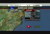
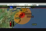
that's all these things combined that makes this such an unusual system. it is still a category 1 hurricane as of the 5:00 p.m. update, still moving northeast at 15 miles per hour. notice how far it is away from the beaches of virginia and north and south carolina and how much damage we've already seen in that area. winds have gusted up near 60 miles per hour. trees have already come down. salisbury, maryland, 47-mile-per-hour wind gusts, 48-mile-per-hour wind gusts in virginia beach and the storm is more than 350 miles away. imagine what's going to happen as the storm makes its way onshore. rainfall amounts already in virginia beach. over two inches of rain at this time and still more to come again as this storm moves closer. taking a tour of the east coast, you can see that winds right now down through the carolinas into virginia, gusting to around 30 to 40 miles per hour. already across new jersey and the shores there and long island, we have gusts 30 to 40 miles per hour and into southern
2:05 pm
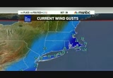
new england winds are gusting 20 to 30 miles per hour. the storm is still so far away. that's kind of the point i want to touch on here is the fact that it is far now, and once it gets closer, that's when we're really going to see all of those effects ramp up. winds could gust near 80 miles per hour. rains could come down torrentially and we will end up to 10 to 12 inches of rainfall. that goes for inland areas, too. that's why we have such a flooding concern for inland areas. it's going to squeeze through this area of high pressure, this stalled front to our west. then it's going to slowly sit over pennsylvania and new york city and new york in general. that's why we are going to see several inch offense rainfall. inland flooding will be an issue as the rivers start to crest their banks. same goes for smaller streams as well. look at the size of this storm. here we go, monday, 2:00 p.m. it extends, the 39-mile-per-hour winds and higher extend from southern new england into northeastern north carolina. then as we go into tuesday morning, you see that middle shade of red there from long
2:06 pm
island all the way down into maryland and delaware. we have winds up to 60 miles per hour and higher with an isolated amount where we could get those winds up to around 74 miles per hour or higher in central and southern new jersey. then eventually as we go into tuesday afternoon, we will still see those tropical storm force winds, the hurricane-force winds make their way into interior pennsylvania. and that's why with the wet ground we will end up with power outages because of downed trees. we are going to get reports of lots of tree damage resulting in the power outage. again torques sum it up here, it's worst for the mid atlantic region monday evening into tuesday morning. that's the peak of the storm. all day monday and all day tuesday are still pretty nasty with the rain coming down and the winds still gusting 40 to 60 miles per hour. we will end up with about 10 to 12 inches of rain in isolated spots. elsewhere, four to eight inches is a lot of water. we will see inland flooding. that storm surge, you a regular high tide and you add four,
2:07 pm
seven, eight, nine, ten feet on top of that. that's that wall of water that's going to move onshore. so coastal flooding obviously a concern. the problem is the peak of the storm comes monday night. the high tide cycle for monday is 6:00 to 9:00 p.m. that's awful timing. that's why we'll see such a major storm surge along the coast. >> talking about the 6:00 to 9:00 timeline because of the full moon basically coming in and joining sandy at that time. >> that's why the tide is actually an astronomically high tide because of the full moon cycle. it's just a combination of events here that is making for an historic storm. >> soaking rains, surf churning wind. it's giving the northeast potentially the taste of what is to come its way. the weather channel's julie martin is live in nags head, north carolina. julie, what are we seeing there? >> reporter: thomas, it is
2:08 pm

interesting. the storm, as she was mentioning, is still so far offshore. we've been dealing with tropical storm force winds now for 17 hours. believe it or not, ever since midnight. that's when tropical storm force wind gusts began. they are continuing here. the winds have backed down just a little bit. i'm protected a bit here by a home. if you take a look out in the atlantic, you can see the tide is starting to come in. we're expecting a high tide here around 30. we have seen some of the tiling on the roof of the restaurant there coming off. just down the road a bit, we have seen also some coastal flooding along the roadways. one of the big roads here, highway 12 which goes to cape hatteras has been shut off all day due to coastal flooding. and ocracoke island, we have reports there of up to 18 inches on the sound side of that island causing problems for people still out there. that is on the far southern end of the outer banks.
2:09 pm

we have seen these intermittent problems. it's really just duration. that's what i'm worried about when it comes to the northeast as well. once sandy passes by us which is going to be sometime around -- between midnight and 2:00 this morning, its center anyway, and it takes that left, you're going to have all this stuff coming onshore for a long, long period of time, at least a couple of days. so that's what we're worried about because here it has been no picnic for two days, let me tell you. we've been dealing with tropical storm force gusts which are around 50. you guys could be dealing with hurricane-force gusts which are at least around 80. it's not going to be a good situation. i hope everyone has been watching us and our coverage down here and has taken note. maybe this has kind of motivated them to get their stuff ready. it's not going to be fun. >> great point about this being a marathon storm. the weather channel's julie martin, appreciate it. further up the coastline to parts of new york city under this mandatory evacuation order.
2:10 pm

some 360,000 residents, most at threat, are being told to get out of harm's way. nbc's michelle franzen is live right now in that affected area. people are obeying this evacuation order and taking heed early or not. how is it going? >> well, i don't have a count on that entire 360,000, but it seems here in battery park city which is part of that zone a which you were mentioning is starting to heed those warnings. you've got hotels in this area and a residential area. in the last few hours we've seen more of a scramble for people to get out of their buildings. it is a mandatory evacuation in those areas. power could be turned off in those buildings. what they're really concerned about, thomas, is that storm surge. here where i'm standing, we're hearing fro jexs of a surge, anywhere between six and 12 inches of the storm surge here. i would be standing in that water and maybe up to the knees or the waste at this point if those projections hold true. as a result the governor has issued that the subway system and the mass transit system here
2:11 pm
in new york city will shut down subways. last train tonight at 7:00, buses after 9:00. then the bridges and tunnels are still open right now. but if the wind picks up in that area, those two could shut down. you've got the physical trading floor down here in lower manhattan, that will be closed down. also broadway shows will not have shows tonight or tomorrow and tuesday, we'll have to wait and see what happens there. that zone a, that low-lying area in and around lower manhattan as well as other boroughs, those mandatory evacuations are in place, it seems like people are taking this seriously. some of the people we talked to had been here during irene and some of them say oh, i might stay, and others are like, no, this seems to be a little more ominous. >> new yorkers can be stubborn when it comes to moving out like this. it does look beautiful so far tonight behind you. we're seeing people out early. >> it's pretty calm. >> the calm before the storm.
2:12 pm

thanks michelle. jerome hour is the new york state commissioner who joins us by telephone. i know you're very busy. what is the biggest concern for new york state and the damage that it could suffer from this storm? we're not just talking about new york city. we have to consider the interior buffalo, syracuse, albany, those major cities as well. >> well, we've got two major concerns. one is the surge from the storm which is going to cause extensive flooding. in the new york city area, all of long island and other spots as you -- westchester and other spots that don't normally flood. the second concern is with the
2:13 pm

sustained high winds. we are very concerned about losing power in significant parts of the state. we are not hearing the things from the weather service. they are very concerned about widespread power outages and extended periods of time when this power could be -- >> you make a great point about the high winds and also the fact that this storm system when it comes on could be a slow-mover, the duration of the high winds. the new york city transit system has taken great precautions, already announcing how it's going to be shutting down in roughly a little more than an hour and a half from now, 7:00 p.m. eastern. the specific concerns for the subways in having time to get them out of harm's way is what? >> well, the reason it was shut down was so that they could start pulling trains out of vulnerable areas and putting them into more protected areas.
2:14 pm

so joe loata in consultation with the governor scheduled it such so that they have time to get the trains and buses into protected areas so they don't wind up with any more damage than we already expect happening. >> what has to happen though before a serious look goes to shutting down city bridges, tunnels, the potential for having them to close as well? >> well, the bridges are a lot easier. when you get up to certain wind speed, you shut the bridges down. it becomes too dangerous to have cars and trucks on them. the tunnels, with the magnitude of the surge that they're predicting, we're very concerned about the water coming over the shoreline, entering subway tunnels, entering the brooklyn battery tunnel and possibly
2:15 pm

entering the holland tunnel. that will cause a major problem. we have to address that when we start seeing the surge. >> sir, for those people that remember irene from 14 months ago and how this storm system is shaping up to be different and people that did theed warning last time and as they're watching this, what is your gut statement to them? what do you want them, those within the storm's path to know firsthand? what's your message? >> my concern is complacency. a lot of people feel that i got through irene, i can get through this. this is a different type of storm. first of all, it's going to cause greater flooding in areas that were not flooded during irene. the wind in areas that were not
2:16 pm

hit by irene with wind problems, those areas -- people really need to take seriously and be prepared. it's almost getting to the point where it's too late because finding food, finding water, finding flashlights and generators is becoming impossible now. >> sir, good advice. hopefully people are getting good advice. jerome hauer, we'll let you get back to work. we appreciate you taking time out of our schedule. this is msnbc's extended coverage of this october surprise, hurricane sandy looming over a huge area of the eastern u.s., threatening to disrupt things for tens of millions of people, over nearly a quarter of the lower 48 states. we're back after this. when a twinge of back pain surprises him. morning starts in high spirits, but there's a growing pain in his lower back.
2:17 pm

as lines grow longer, his pain continues to linger. but after a long day of helping others, he gets some helpful advice. just two aleve have the strength to keep back pain away all day. today, jason chose aleve. just two pills for all day pain relief. try aleve d for strong, all day long sinus and headache relief. i wish my patients could see what i see. ♪ that over time, having high cholesterol and any of these risk factors can put them at increased risk for plaque buildup in their arteries. so it's even more important to lower their cholesterol, and that's why, when diet and exercise alone aren't enough, i prescribe crestor. in a clinical trial versus lipitor, crestor got more high-risk patients' bad cholesterol to a goal of under 100. [ female announcer ] crestor is not right for everyone. like people with liver disease or women who are nursing, pregnant or may become pregnant. tell your doctor about other medicines you're taking. call your doctor right away
2:18 pm

if you have muscle pain or weakness, feel unusually tired, have loss of appetite, upper belly pain, dark urine or yellowing of skin or eyes. these could be signs of rare but serious side effects. ♪ is your cholesterol at goal? talk to your doctor about crestor. [ female announcer ] if you can't afford your medication, astrazeneca may be able to help. [ female announcer ] if you can't afford your medication, when you take a closer look... ...at the best schools in the world... ...you see they all have something very interesting in common. they have teachers... ...with a deeper knowledge of their subjects. as a result, their students achieve at a higher level. let's develop more stars in education. let's invest in our teachers... ...so they can inspire our students. let's solve this.

2:20 pm

to new england, it's a watch and wait for hurricane sandy. nbc's don truong is in rojo both beach to tell us how they're faring there. a lot of people will be familiar with this hammett. weekend warriors for baltimore and d.c. go to ro hob hoeb both a lot. >> this is now coming in to high tide just a few hours ago. the water is pushed back about 50 yards thomas. if you want to take a closer look, there's a daring body border, wake border going into the water right now. this is an area under a mandatory evacuation order, roughly 50,000 people are supposed to get out of harm's way, coastal delaware. they have until 8:00. at that time authorities will start looking down and cutting off the roads and bridges coming into r ofrnltshoboth beach, expecting to what they expect to
2:21 pm

be coat coastal erosion, beach oh roegs. storm surges expected to be four to eight feet. also expecting eight inches of rain. in the last three hours we noticed the rain is morstead difficult. we're still hours away before we feel the initial impacts. you look at all the sea foam and all this water coming onto the beach, this is a taste of what we're going to expect over the next 24 to 36 hours. you saw probably at the top of the show julie martin talking about what the conditions are like there. now we're starting to see it as well. they have about 2,000 extra utility workers on standby because they're anticipating wide power outages in the next couple days. that's why the governor here ordered that mandatory evacuation order for the coastal areas of delaware. he's anticipating once the power goes out, they're basically going to be cut off and potentially for a few days without power. because of this late season storm it is cold. nobody is really mentioning that. i've covered enough storms. it's been in a tropical humid
2:22 pm

climate. right now it's pretty cold, thomas, back to you. >> talk about the mandatory evacuations and one thing that most governors and city officials have been trying to warn people about, specifically with that boogie border is to stay out of the border. if something does happen to you, you put other people, the first responders, their lives in danger by having to come out and get you. do you see patrols on the beach or people nearby that will come and start forcing people like that boogie border to get out of the water? >> we did see a few lifeguards here. there's a patrol area here. it's basically a ghost town, tom. as you know as well as anybody, this is a very popular spot for beach tourists, there was a huge festival, the sea witch festival yesterday, over 70,000 people were basically in here shoulder to shoulder. this whole area was packed and within 24 hours it's now gone. if anything does happen, i don't see anybody that would come to his aid. that's what people and especially governors have been
2:23 pm

warning people about. if you get in trouble, they can't guarantee you'll get help. if you do get help, you might be taking that first responder unnecessarily away from another, quote, unquote, emergency. they hope people heed the warnings. folks here have until 8:00 and that's when things start clamping down. >> big waves can look fun. but it is dangerous. >> tom truong joining us from rohoboth beach. joining us from delaware is governor jack markell. i know you've been following the updates on the state website for delaware. at this time explain where things stand in the state of emergency. i know you added not a long time ago about businesses shutting down. >> thanks for having me. yesterday we announced mandatory evacuations for people along our coast. we laid it out in great detail. those people should be gone by 8:00 tonight. businesses and those areas need
2:24 pm

to be closed by 6:00 tonight. we've got a lot of first responders across the state working cooperatively. as your report just now said, people have to take responsibility. otherwise they put themselves and others in harm's way. >> as you're saying that we're watching a boogie border on the beach heading out to the waves right now. >> if people are going to do stupid things, that's their problem. the fact is, people stay in these evacuation areas, they could be cut off. this is not a police state and people have to take a certain amount of responsibility and that's what we expect they'll do. >> as you bring up the personal responsibility, the biggest problem is not that you just want to make sure this person is safe, but it also puts first responders at risk if they get called to the beach to save somebody. >> exactly. people in the bay areas, we told them yesterday they have until 8:00 tonight, otherwise they're going to be cut off. we don't want to lose a first responder to go in after
2:25 pm

somebody who could have gotten themselves out. if people need help with evacuation, we certainly can help with that. we've opened up shelters across the state. we've got hundreds and hundreds and hundreds of people across the state who are working across the various agencies to be of support. people have to take care of themselves as well. >> how are you able to communicate mainly with people to get out the message but to get out information on where they can go for potential shelters, potential evacuation shelters if necessary. >> we're grateful to you and other media for helping to get the message out. we're using social media. delaware.gov has information. also aggressively using facebook and twitter. it's a whole new world in terms of communicating with people during these storms. >> governor, from what you've been getting from your reporting and what you've been looking at from these mod des, how does this differ from irene?
2:26 pm

>> number one, even though we're hours from having the center of it hit, we're seeing the kind of tidal activity and flooding that you'd normally see at the height of the storm. that's number one. number two, we're expecting the storm to stay with us. it's slow moving which is a problem because it's going to last over several tidal cycles. we also expect to be, once we're out of power, we expect it's going to be a while before the power comes back on because it could take a while for the utility companies to send their people out. >> governor jack markell, thanks for joining me today. the governor of delaware. if parents are wondering where their son is, not sitting there watching tv with you, he might be that kid out there. >> thank you very much. we continue to cover the track of hurricane sandy. the public services up and down the eastern seaboard. all of this concern happens amid the last week of the
2:27 pm

extraordinarily tight presidential campaign. storm coverage and a turn to politics all straight ahead on politics all straight ahead on msnbc. whole grain, multigrain cheerios! mom, are those my jeans? [ female announcer ] people who choose more whole grain tend to weigh less than those who don't. multigrain cheerios [ ding! ] ...and spend time on the slopes. take alka-seltzer plus cold & cough... [ buzz! ] ...and spend time on the chair. for non-drowsy 6-symptom cold & flu relief. take dayquil. use nyquil... [ ding! ] ...and get longer nighttime cough relief. use alka-seltzer plus night cold & flu... [ coughs ] [ buzz! ] [ screams ] ...and you could find yourself... honey? ...on the couch. nyquil. 50% longer cough relief.

2:29 pm

throughout our lives. one a day men's 50+ is a complete multi-vitamin designed for men's health concerns as we age. it has more of 7 antioxidants to support cell health. one a day men's 50+. that makes tv even better. if your tv were a prom queen, zeebox would be a stretch limo. with this enchanting union, comes a sunroof she can scream from... i'm goin' to prom! [ male announcer ] ...and a driver named bruce that she can re-name james... faster, james! [ male announcer ] ...just 'cause. download zeebox free, and have the night of your life with your tv.
2:30 pm

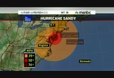
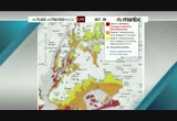
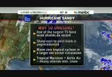
welcome back everybody. hurricane sandy is bearing down on the eastern seaboard. the latest advisory says the storm is expected to have life-threatening storm surge. we get the latest now from nbc news meteorologist dylan dreyer. dylan, when do we know the model is predicting an accurate landfall? >> it's an interesting situation. normally when we talk about a hurricane, it's exactly where that eye of the storm crosses over land where we see our biggest impacts. but because this storm is so huge, no matter where you are in the jersey shore, long island, new york city itself, down through delaware, down into maryland, we're all going to feel similar effects. that rough surf, the storm surge up to around four to even ten, eleven feet high and then the torrential rains and then the extreme gusty winds. look at this situation. i want to explain to you what's going on and why we are all saying this is such an historic event. here we see the storm swirling well to the east of the
2:31 pm

carolinas, still more than 300 miles to the east. look how the rain extends into southern new jersey, delaware and washington, d.c. you see what's going on back through ohio, into the pittsburgh area? that's the cold front. it's not moving west to east like norming, it's moving east to west. all of this is making for an unusual setup. here is factor number one. in a normal situation when you have this hurricane over the atlantic, it gets picked up in the jet stream and shoots right out to sea, no threat to land. however, this time around we have this huge ridge up into greenland, this huge blocking high pressure system. so the jelt stream is actually getting pinched off and it's drawing in the storm. it's going to make landfall somewhere in the new jersey area along the jersey shore. that's factor number one. factor number two, look at the sheer size of this storm. the tropical storm force winds extend from southern new hampshire all the way down into northeastern north carolina.
2:32 pm
the 58-mile-per-hour-plus winds extend from long island down into maryland. this is a huge storm, especially for the atlantic. and one of the largest storms we've ever seen. if we pile all this together, why is this such an historic event? this is one of the largest tropical storm force windshields on record, to extend all the way from southern new england down into the carolinas, it's just massive. on top of that, this sharp east-to-west track is unprecedented. the first storm to move in to affect new york city, new jersey, the shores of maryland and delaware, that's unpreced t unprecedented. on top of that, we're going from this tropical cyclone embedded in the larger nor'eastern situation. that makes it unusual. on the back side of this storm, the tropical moisture is going to mix with arctic air. that's going to create some heavy interior mountain snow,
2:33 pm
especially west virginia. we could see several inches of snow because there's so much moisture and eventually so much cold air working into this system. this is a bizarre event. what does it mean for us? again, we're talking about those gusty winds, especially monday night. they could gust near 80 miles per hour. we're looking at perhaps a foot of rainfall. we're looking for a storm surge perhaps up to 10 or 11 feet high. this is going to create major concerns across the eastern seaboard. it doesn't really matter where you are, from southern new england all the way down into north carolina we are going to see these issues with power outages and so on as we go through the weekend. >> sandy is taking a huge swath out of the eastern seaboard. thank you so much. we talk about the fact that this storm has yet to make the northwest ward turn. right in its forecast, the new jersey coastline. nbc's jay gray joins me from cape may, new jersey. it looks calm ananias so far. >> reporter: what we've seen is
2:34 pm

the rain and wind picked up a bit. right now it's a lull which is good news because a lot of people boarding up windows deciding if they'll move to higher ground. emergency officials warning that time is running out. we push to the shoreline. we move from that shoreline due to the fact that they're expecting such a storm surge. as dylan talked about, a massive system, slow moving. we'll see it move in during what is a peak high tied. those waves will increase dramatically and push in. the flooding will be a serious issue. then you've got the massive size which means the rain is going to continue in some areas for 36 hours. that's too much water for many of these coastal communities to bear. so they're doing what they can to prepare. there's a mandatory evacuation right here now and in several towns along the coastline. many people very concerned, taking the warnings, taking the advice very seriously and waiting to see exactly what
2:35 pm

sandy does. let's take a look at some of the preparations that are continuing and right now nine states have declared states of emergency as does the district of columbia, washington. there is a lot of last minute work going on. again, emergency officials telling us and stressing, asking that we get the word out. if you don't have things in place, if you don't have a plan in place to go somewhere by the end of this evening, you've got to hunker down and ride this thing out because it's going to be much too late. a significant water event. they believe there will be millions without power. some of those will be without electricity for perhaps a week or longer. so those that are buying supplies and deciding to ride this thing out, need to realize they'll need those supplies for an extended period of time. thomas, everyone is talking about this is a different event than many of us have ever seen. >> unprecedented. nbc's jay gray. with the general election a little more than one week away,
2:36 pm

early voting started on saturday in maryland. voters splitting their time between heading to the polls and prepping for hurricane sunday. tomorrow, early voting has been canceled a sign of how seriously officials are taking this storm. carolyn miletti joins us. it's god to have you with us tonight. forecasters are calling this is most damaging storm to hit in 75 years. while we talk about the eastern shoreline of maryland, a lot of people need to remember the chesapeake bay and all the water that can surge up into balt more and the inner harbor. is that one of your biggest concerns, the storm surge from this? >> actually it's not. this system will have the opposite effect that hurricane isabelle and hurricane irene had last year. we're looking for higher surges on the atlantic coastal side.
2:37 pm

we'll see normal surges into the chesapeake bay because the storm is tracking so far north of the chesapeake bay. >> when we look at whether or not it matters if maryland takes a direct hit or not, as you say that storm surge along the eastern coastline from ocean city and further south is still a big concern. >> yes, it is. ocean city has implemented a mandatory evacuation that has been completed. they heed the warning both from a voluntary perspective yesterday and a mandatory perspective today. we're confident that those citizens have been moved out of harm's way. >> as we've been talking about the storm surge, there's also the potential for high winds, people expecting power outages to happen from different states. what are the preparations that maryland has made specifically to ensure and prepare for the definite likelihood of power outages that don't last for weeks on end?
2:38 pm

>> exactly. maryland is covered by five power company providers. at this time we have pre positioned 3,600 crews and tree trimmers and individuals. we have over 226 mutual aid assistance crews coming to assist us. but the uniqueness with this storm is going to be the stalling effect and the sustained winds of 24 to 34 knots where some of our power company crews will not be able to put up their bucket trucks because of a safety hazard. we may see a potential for 30 to 48 hours that we'll not be able to to start the restoration which we normally would start after a normal hurricane event. >> ken mallette from the maryland emergency management office. thanks for joining us. the emergency has pulled president obama back to washington pulling him off the campaign trail. the president's response to the threat of hurricane sandy and
2:39 pm

other politics coming up. keep it right here. this is msnbc's continuing coverage of hurricane sandy's track. we're back in a moment. and we got onesies. sometimes miracles get messy. so we use tide free. no perfumes or dyes for her delicate skin. brad. not it. not it. just kidding. that's our tide. what's yours?
2:40 pm

i just finished a bowl of your new light chicken pot pie soup and it's so rich and creamy... is it really 100 calories? let me put you on webcan... ...lean roasted chicken... and a creamy broth mmm i can still see you. [ male announcer ] progresso. you gotta taste this soup. at legalzoom, we've created a better place to turn for your legal matters. maybe you want to incorporate a business you'd like to start. or protect your family with a will or living trust. legalzoom makes it easy with step-by-step help when completing your personalized document -- or you can even access an attorney to guide you along. with an "a" rating from the better business bureau legalzoom helps you get personalized and affordable legal protection. in most states, a legal plan attorney is available with every personalized document

2:42 pm

welcome back. we're keeping up our continuing coverage of msnbc's current track of hurricane sandy as it bears down on the eastern coastline. this storm is now churning in the atlantic, is expected to come ashore monday night. officials are taking precautions now. a lot of them in new york. governor cuomo ordered all subway, bus and commuter rail service in and around new york city begin shutting down tonight at 7:00 p.m. eastern. that's less than 90 minutes from now. president obama off the campaign trail today making an afternoon visit to fema where he called the storm big and serious and slow moving. >> we're going to have to make sure that we are vigilant and vigilant for a couple of days
2:43 pm

don't anticipate that just because the immediate storm has passed that we're not going to have some potential problems in a lot of these communities going forward through the week. >> president obama today at fema headquarters, the president again taking time off the campaign trail to focus on exactly what this storm is going bring to people along the eastern seaboard. >> joining me is kelly goff from theroot.com. you are affected by this. >> i'm an evacuee officially as of now. >> we can keep your mind off of it -- >> i'm going to be staying here after we're done. that's the only reason i agreed to come on. >> the precedent for something like this, the storm like this, the real october surprise is taking people off course when we're talking about early voting in certain states like maryland who said they will not have early voting tomorrow. >> not just early voting. what we actually don't know is
2:44 pm

the big question is what happens if the power goes out for several days. we're not far out from the election here. there is a big concern in terms of early voting and day-of voting. if we're having problems with counting votes that can prove to be a problem in a close election. i interviewed congressman daniel cleve clever. it's not much when you're talking about states like virginia where it's goings to be really, really tight. this is the october surprise to end all october surprises in terms of how the election can turn out. >> we were watching today. craig melvin was reporting from florida. one thing, this did not stop the politicos to get on "meet the press" today to talk about sandy. rachel ma dough wddow was one o guests. >> one of the things we saw was tina fey speaking in new york who seemed to strike the court about going beyond abortion,
2:45 pm

about do you trust women enough to let them make decisions about their own lives. this is how she talked about it. >> if i have to listen to one more gray-faced man with a $2.00 haircut explain to me what rape is, i'm going to lose my mind. >> frankly, to be fair, the romney campaign is thinking the same thing, i'm going to lose my mind if we have to keep talking about rape in this election because its an association with the republican party that he does want to be associated with. >> right. but then he picked paul ryan. the government telling you need to have a medically necessary procedure at the order of the state regardless of what you want and regardless of what your doctor says. he picked a guy if favor of a forced ultrasound bill. paul ryan was a co-sponsor of a bill to have person hood federally which would not only ban all abortion, but all
2:46 pm

hormonal forms of birth control. if you want to avoid this fight, don't pick paul ryan. >> mitt romney has better ratings than the republican party overall. the democratic party has better favorable ratings than the democratic party overall? if mitt romney doesn't win i think the fault lies is because their image took a turn to the right that romney himself should be able to win. >> voters vote for people, not parties. romney is on the ticket, not the republican party. >> kelly, the coverage of sandy is actually going to take media attention and focus for the candidates as well as place it on the storm and the people affected while we do talk about early voting. the conversation that's been leading up to this are debates coming out of indiana with mourdock and talking about abortion, are those instances an
2:47 pm

anchor around romney's neck? >> yes. the reason i say that, he gained quite a bump after the first debate which we know was not a great showing for president obama. we saw his high digit lead start to shrink after that debate. what happens is we start to see binders full of women. we hear mourdock's not so helpful comment. and the thing i left out, too, is president obama and the dnc have been hammering home is this who you want, is this the policy you want if you're a female voter? we know romney is worried about that because he started running an ad where you had a woman says i thought romney was bad on issues. and another woman saying no, no, no, he's not bad. they're mischaracterizing him. >> is it the fact that people might be afraid of the republican party or afraid of mitt romney specifically? i think the narrative might be changing that people might like mitt romney. i like my congressman, i don't like congress. >> the challenge for him is the etch a sketch narrative which is
2:48 pm

people feel they don't know entirely where he stands. for instance, mccain was known as the renegade. if someone criticized the gop, mccain is different, he's a maverick. with mitt romney we're not exactly sure. he's perceived as someone who switches positions so many times that you're not sure what his position is. when someone says something negative, how are you sure it's not true? one of the things it didn't show, one of his surrogates who said abortion isn't an important issue. he was speaking on behalf of the romney campaign. that's an anchor. that's when you start seeing the incanninging. >> is there still time for mitt romney to change the narrative? he has not come out to talk about what mourdock said. a campaign person said we disavow that statement. but the endorsement still runs. >> and the ad is still running and he's avoiding the media. which doesn't exactly scream not worried.
2:49 pm

the best way to convince the media and the public that you're not worried is to avoid them talking about it. the only way to change the narrative is for him to have the courage to define his position. i've talked to plenty of republican friends who said i'm pro life and i even think what mourdock said was extreme. i think because it's a tight race, he knows the gop base could make or break the race. he's fearful if he cuts mourdock loose, there's so pro lifers, the huck key camp who says i'm going to cut him loose. >> kelly goff with theroot.com and fresh new resident at 30 rock. she now lives here. hurricane sandy is yet to make what is expected to be the major westward turn toward the west coast. its impact in terms of the wind and high ser of are already becoming more severe. we continue to track the storm as msnbc's extended coverage of hurricane sandy continues. we're back in a moment.


2:53 pm

obviously a serious storm. it's a serious storm that is going to affect most of the east coast from north carolina up to new england. but, it's going to make land fall in new jersey. that's clear. where in new jersey, we are not quite clear. ift appears it will make land fall between atlantic city and toms river. what that means for us is of the states impacted by the storm, we appear at the moment to be taking the brunt of it. so, we have to take this seriously. >> so, if you are on the east coast of the u.s. planning to fly in the next 36 to 48 hours or if you are somewhere else hoping to fly into the eastern u.s. anytime soon, it is a safe bet to say you need to rethink
2:54 pm

those plans. airlines canceled thousands of flights. the airports are expected to close. tom costello joins us from reagan national airport. tell us about the ripple effect. >> reporter: in the last hour and a half we went from wearing a light fleece to a full winter jacket. the winds picked up. it is really cold. behind me, on the ramp, we have a lot of planes out here. they are going to be leaving and probably not coming back tonight. we are looking at 1200 flight cancellations. so far, along the east coast a total of four and a half to 5,000. according to the airport staff, we draw your attention to philadelphia airports. we have significant delays tonight from anywhere to an hour to two or three hours for inbound flights because they are having a hard time getting there
2:55 pm

from their original point of departure. united, delta, jetblue, all the big boys, seven hubs affected by the storm. let me show you another website. this is flight radar 24. it shows you all the planes in the skies right now over north america. you are going to see the east coast of the united states. this radar with all the planes will become really empty sometime tonight or into tomorrow as the east coast empties out. these major carriers are moving their planes out of harm's way, out of the way of sandy. if you have a flight booked for the next two days, chances are you are going to have to rebook. the airlines are waiving the fees. the ripple effect across the entire country as planes are out of position, crews are out of position, this becomes a problem. i want to make a point amtrak is
2:56 pm

cannesling service between d.c. and new york because of the storm. the ripple effect across the busiest part of the transportation grid in this country is quite profound. thomas, one more time, seven different airport hubs affected by all this activity. >> when we talk about the different airlines waiving fees, uniformly they have gone across the board to waive fees? >> pretty much. pretty much across the board, if your flight, your city is affected by the storm, they are waiving the change fees. >> tom costello reporting, thanks so much. we appreciate you sticking with us. we are coming up on the 6:00 hour. msnbcs extended coverage of hurricane sandy continues in the next hour. stay with me. new prilosec otc wildberry
2:57 pm
is the same frequent heartburn treatment as prilosec otc. now with a fancy coating that gives you a burst of wildberry flavor. now why make a flavored heartburn pill? because this is america. and we don't just make things you want, we make things you didn't even know you wanted. like a spoon fork. spray cheese. and jeans made out of sweatpants. so grab yourself some new prilosec otc wildberry. [ male announcer ] one pill each morning. 24 hours. zero heartburn. satisfaction guaranteed or your money back. satisfaction guaranteed so i test... a lot. do you test with this? freestyle lite test strips? i don't see... beep! wow! that didn't take much blood. yeah, and the unique zipwik tab targets the blood and pulls it in. so easy. yep. freestyle lite needs just a third the blood of onetouch ultra. really? so testing is one less thing i have to worry about today. great. call or click today and get strips and a meter free. test easy.

2:59 pm

oh, hey alex. just picking up some, brochures, posters copies of my acceptance speech. great! it's always good to have a backup plan, in case i get hit by a meteor. wow, your hair looks great. didn't realize they did photoshop here. hey, good call on those mugs. can't let 'em see what you're drinking. you know, i'm glad we're both running a nice, clean race. no need to get nasty. here's your "honk if you had an affair with taylor" yard sign. looks good. [ male announcer ] fedex office. now save 50% on banners.
100 Views
IN COLLECTIONS
MSNBC West Television Archive
  Television Archive News Search Service
Uploaded by TV Archive on
